Drawing a line/path on Google Maps
Thank you for your help. At last I could draw a line on the map.
This is how I done it:
/** Called when the activity is first created. */
private List<Overlay> mapOverlays;

private Projection projection;

@Override
public void onCreate(Bundle savedInstanceState) {
    super.onCreate(savedInstanceState);
    setContentView(R.layout.main);

    linearLayout = (LinearLayout) findViewById(R.id.zoomview);
    mapView = (MapView) findViewById(R.id.mapview);
    mapView.setBuiltInZoomControls(true);

    mapOverlays = mapView.getOverlays();
    projection = mapView.getProjection();
    mapOverlays.add(new MyOverlay());

}

@Override
protected boolean isRouteDisplayed() {
    return false;
}

class MyOverlay extends Overlay{

    public MyOverlay(){

    }

    public void draw(Canvas canvas, MapView mapv, boolean shadow){
        super.draw(canvas, mapv, shadow);

        Paint   mPaint = new Paint();
        mPaint.setDither(true);
        mPaint.setColor(Color.RED);
        mPaint.setStyle(Paint.Style.FILL_AND_STROKE);
        mPaint.setStrokeJoin(Paint.Join.ROUND);
        mPaint.setStrokeCap(Paint.Cap.ROUND);
        mPaint.setStrokeWidth(2);

        GeoPoint gP1 = new GeoPoint(19240000,-99120000);
        GeoPoint gP2 = new GeoPoint(37423157, -122085008);

        Point p1 = new Point();
        Point p2 = new Point();
        Path path = new Path();

        Projection projection=mapv.getProjection();
        projection.toPixels(gP1, p1);
        projection.toPixels(gP2, p2);

        path.moveTo(p2.x, p2.y);
        path.lineTo(p1.x,p1.y);

        canvas.drawPath(path, mPaint);
    }
How do I draw a route, along an existing road, between two points?
Indeed, you can draw precise route in Google Maps Android API using results provided by Directions API web service. If you read the documentation for Directions API you will see that response contains information about route legs and steps. Each step has a field polyline that is described in the documentation as
polyline contains a single points object that holds an encoded polyline representation of the step. This polyline is an approximate (smoothed) path of the step.
So, the main idea to solve your issue is to get response from Directions API, loop through route legs and steps, for each step get encoded polyline and decode it to the list of coordinates. Once done you will have a list of all coordinates that compound the route, not only begin and end point of each step.
For simplicity I recommend using the Java client library for Google Maps Web services:
https://github.com/googlemaps/google-maps-services-java
Using this library you can avoid implementing your own async tasks and decoding function for polylines. Read the documentation to figure out how to add the client library in your project.
In Gradle it should be something similar to
compile 'com.google.maps:google-maps-services:(insert latest version)'
compile 'org.slf4j:slf4j-nop:1.7.25'
I have created a simple example to demonstrate how it works. Have a look at my comments in the code
public class MapsActivity extends FragmentActivity implements OnMapReadyCallback {

    private GoogleMap mMap;
    private String TAG = "so47492459";

    @Override
    protected void onCreate(Bundle savedInstanceState) {
        super.onCreate(savedInstanceState);
        setContentView(R.layout.activity_maps);
        // Obtain the SupportMapFragment and get notified when the map is ready to be used.
        SupportMapFragment mapFragment = (SupportMapFragment) getSupportFragmentManager()
                .findFragmentById(R.id.map);
        mapFragment.getMapAsync(this);
    }

    @Override
    public void onMapReady(GoogleMap googleMap) {
        mMap = googleMap;

        LatLng barcelona = new LatLng(41.385064,2.173403);
        mMap.addMarker(new MarkerOptions().position(barcelona).title("Marker in Barcelona"));

        LatLng madrid = new LatLng(40.416775,-3.70379);
        mMap.addMarker(new MarkerOptions().position(madrid).title("Marker in Madrid"));

        LatLng zaragoza = new LatLng(41.648823,-0.889085);

        //Define list to get all latlng for the route
        List<LatLng> path = new ArrayList();


        //Execute Directions API request
        GeoApiContext context = new GeoApiContext.Builder()
                .apiKey("YOUR_API_KEY")
                .build();
        DirectionsApiRequest req = DirectionsApi.getDirections(context, "41.385064,2.173403", "40.416775,-3.70379");
        try {
            DirectionsResult res = req.await();

            //Loop through legs and steps to get encoded polylines of each step
            if (res.routes != null && res.routes.length > 0) {
                DirectionsRoute route = res.routes[0];

                if (route.legs !=null) {
                    for(int i=0; i<route.legs.length; i++) {
                        DirectionsLeg leg = route.legs[i];
                        if (leg.steps != null) {
                            for (int j=0; j<leg.steps.length;j++){
                                DirectionsStep step = leg.steps[j];
                                if (step.steps != null && step.steps.length >0) {
                                    for (int k=0; k<step.steps.length;k++){
                                        DirectionsStep step1 = step.steps[k];
                                        EncodedPolyline points1 = step1.polyline;
                                        if (points1 != null) {
                                            //Decode polyline and add points to list of route coordinates
                                            List<com.google.maps.model.LatLng> coords1 = points1.decodePath();
                                            for (com.google.maps.model.LatLng coord1 : coords1) {
                                                path.add(new LatLng(coord1.lat, coord1.lng));
                                            }
                                        }
                                    }
                                } else {
                                    EncodedPolyline points = step.polyline;
                                    if (points != null) {
                                        //Decode polyline and add points to list of route coordinates
                                        List<com.google.maps.model.LatLng> coords = points.decodePath();
                                        for (com.google.maps.model.LatLng coord : coords) {
                                            path.add(new LatLng(coord.lat, coord.lng));
                                        }
                                    }
                                }
                            }
                        }
                    }
                }
            }
        } catch(Exception ex) {
            Log.e(TAG, ex.getLocalizedMessage());
        }

        //Draw the polyline
        if (path.size() > 0) {
            PolylineOptions opts = new PolylineOptions().addAll(path).color(Color.BLUE).width(5);
            mMap.addPolyline(opts);
        }

        mMap.getUiSettings().setZoomControlsEnabled(true);

        mMap.moveCamera(CameraUpdateFactory.newLatLngZoom(zaragoza, 6));
    }
}
Please note that for web service you have to create a separate API key, the API key with Android app restriction won't work with web service.
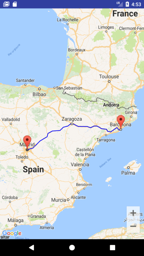
The result of my example is shown in screenshot
You can also download a complete sample project from
https://github.com/xomena-so/so47492459
Don't forget replace the API key with yours.
I hope this helps!
how to draw path between 2 points on google map
you can use the latest google api
http://developer.android.com/google/play-services/maps.html
thre are lot of links available for this. take a look on
Drawing a line/path on Google Maps
How to Draw Route in Google Maps API V2 from my location
Android: How to draw route directions google maps API V2 from current location to destination
How to draw a path as a straight line in google maps?
Isn't straight what is given in the official docs, as well?
Still, Here is a fiddle for you to play with.
var mapOptions = { zoom: 2, center: new google.maps.LatLng(0, 60) };
var map = new google.maps.Map(document.getElementById('map-canvas'), mapOptions);
var path = [
new google.maps.LatLng(10,20),
new google.maps.LatLng(0,40),
new google.maps.LatLng(50,60)];
var pathOptions = { path: path, strokeColor: "red", strokeWeight: 2 }
var myPath = new google.maps.Polyline(pathOptions);
myPath.setMap(map);
How to draw line on google maps
The simplest way is to use a GMSPolyline.
Assuming you have a coordinates array of CLLocationCoordinate2D's and they are in the correct order.
let path = GMSMutablePath()
for coord in coordinates {
    path.add(coord)
}
let line = GMSPolyline(path: path)
line.strokeColor = UIColor.blue
line.strokeWidth = 3.0
line.map = self.map
drawing a line path in google map with GPS co-ordinates
try this
DEMO
function initialize(){
   var center= new google.maps.LatLng(10.012869,76.328802);
   var myOptions = {
            zoom: 18,
            center: center,
            mapTypeControl: true,
            mapTypeControlOptions: {style: google.maps.MapTypeControlStyle.DROPDOWN_MENU},
            navigationControl: true,
            mapTypeId: google.maps.MapTypeId.HYBRID
   }
  var map = new google.maps.Map(document.getElementById("map_canvas"), myOptions);

  var polylineCoordinates = [
        new google.maps.LatLng(10.013566,76.331549),
        new google.maps.LatLng(10.013566,76.331463),
        new google.maps.LatLng(10.013503,76.331313),
        new google.maps.LatLng(10.013482,76.331205),
        new google.maps.LatLng(10.013419,76.330926),
        new google.maps.LatLng(10.013334,76.330712),
        new google.maps.LatLng(10.013313,76.330411),
        new google.maps.LatLng(10.013292,76.330175),
        new google.maps.LatLng(10.013228,76.329854),
        new google.maps.LatLng(10.013144,76.329553),
        new google.maps.LatLng(10.013059,76.329296),
        new google.maps.LatLng(10.012996,76.329017),
        new google.maps.LatLng(10.012869,76.328802),
        new google.maps.LatLng(10.012785,76.328545),
        new google.maps.LatLng(10.012700,76.328223),
        new google.maps.LatLng(10.012679,76.328030),
        new google.maps.LatLng(10.012658,76.327837),
        new google.maps.LatLng(10.012637,76.327600),
        new google.maps.LatLng(10.012573,76.327322),
        new google.maps.LatLng(10.012552,76.327043),
        new google.maps.LatLng(10.012552,76.326807),
        new google.maps.LatLng(10.012510,76.326613),
        new google.maps.LatLng(10.012447,76.326399),
        new google.maps.LatLng(10.012404,76.326227),
  ];
  var polyline = new google.maps.Polyline({
      path: polylineCoordinates,
      strokeColor: '#FF0000',
      strokeOpacity: 1.0,
      strokeWeight: 2,
      editable: true
  });

  polyline.setMap(map);

}


initialize();
draw different route line between multiple markers maps
Currently you are stringing all the results together in a single polyline. The directions service is asynchronous, the results may come back in a different order than sent. One solution is to make each independent directions result a separate polyline. If you need them combined into a single polyline, you need to keep track of the order and put them together in the correct order.
- related question: Inconsistent behaviour drawing a route between two points in Google Maps v3
- related question: Remove straight line in google map path using javascript
proof of concept fiddle
code snippet:
var geocoder;var map;
function initialize() {  var map = new google.maps.Map(    document.getElementById("map_canvas"), {      center: new google.maps.LatLng(37.4419, -122.1419),      zoom: 13,      mapTypeId: google.maps.MapTypeId.ROADMAP    });  var lat_lng = [    new google.maps.LatLng(19.449045, -99.1588115),    new google.maps.LatLng(19.54951, -99.20688),    new google.maps.LatLng(19.4219738, -99.0992125),    new google.maps.LatLng(19.446199, -99.1609357),    new google.maps.LatLng(19.54578,-99.206918),    new google.maps.LatLng(19.503391,-99.201939)
  ];  for (var t = 0;    (t + 1) < lat_lng.length; t++) {    //Intialize the Direction Service    var service = new google.maps.DirectionsService();    var directionsDisplay = new google.maps.DirectionsRenderer();
    var bounds = new google.maps.LatLngBounds();    if ((t + 1) < lat_lng.length) {      var src = lat_lng[t];      var des = lat_lng[t + 1];      service.route({        origin: src,        destination: des,        travelMode: google.maps.DirectionsTravelMode.DRIVING      }, function(result, status) {        if (status == google.maps.DirectionsStatus.OK) {          // new path for the next result          var path = new google.maps.MVCArray();          //Set the Path Stroke Color          // new polyline for the next result          var poly = new google.maps.Polyline({            map: map,            strokeColor: '#4986E7'          });          poly.setPath(path);          for (var k = 0, len = result.routes[0].overview_path.length; k < len; k++) {            path.push(result.routes[0].overview_path[k]);            bounds.extend(result.routes[0].overview_path[k]);            map.fitBounds(bounds);          }        } else alert("Directions Service failed:" + status);      });    }  }}google.maps.event.addDomListener(window, "load", initialize);
html,body,#map_canvas { height: 100%; width: 100%; margin: 0px; padding: 0px}<script src="https://maps.googleapis.com/maps/api/js"></script><div id="map_canvas"></div>Related Topics
Android Listview With Different Layouts For Each Row
How to Check If a Service Is Running on Android
How to Enable or Disable the Gps Programmatically on Android
How to Connect to a Specific Wi-Fi Network in Android Programmatically
How to Change the Status Bar Color in Android
Find Location of a Removable Sd Card
How to Copy Files from 'Assets' Folder to Sdcard
Android: Install .Apk Programmatically
How to Add Parameters to Httpurlconnection Using Post Using Namevaluepair
Firebase Android: Make Username Unique
How to Convert a Drawable to a Bitmap
Failed to Resolve: Com.Android.Support:Cardview-V7:26.0.0 Android
Android Asynctask Sending Callbacks to Ui
How to Change an Application Icon Programmatically in Android
How to Make Links in a Textview Clickable
Maintain/Save/Restore Scroll Position When Returning to a Listview
How to Add the New "Floating Action Button" Between Two Widgets/Layouts